Malaysia Peninsular Cool Highland, Kedah, Jerai Hill 马来西亚半岛,吉打州属,日莱峰


Malaysia Peninsular Cool Highland, Kedah, Jerai Hill
马来西亚半岛,吉打州属,日莱峰
Gunung Jerai (Mount Jerai) rises
above the surrounding plains at 1380metres/4140 feet above sea level and is
visible for miles around. 11kms of winding road lead up to this mountain resort
which can be reached by car. The vegetation begins to change gradually as you
ascend the mountain - through the lower and upper dipterocarp forests that we
commonly encounter in parks and reserves down in valleys and low lying areas
that give way to the low montane forest where conifers thrive.
At the top of the mount the trees
are much shorter in height, twisted and gnarled from the base to the branches.
It certainly is a delight to step off the cemented trails and onto the soft
forest floor - nature's best carpeting, thickly covered with layers of acid
humus soil and peat.
The forest is saturated with
delicious scents. A wonderful mixture of balsamic fragrances from various types
of coniferous and oak trees gives the forest a rather alien feel. It's like
walking into a curio shop in a little seaside town - everything seems so
strangely out of place.
Just a short distance away from the
resort, sits the forestry's museum. The displays give a fair bit of information
on the Malaysian forests. However, a number of displays do not have English
placards and can be frustrating for some. There is also a section dedicated to
wildlife found within the Jerai Forest Reserve area. Guides can be arranged for
trekking expeditions in the reserve park through the rangers at the forestry's
museum.
Dusky Leaf Monkeys are common
around the area and can often be seen feeding on trees at the quieter end of
the road leading to the old shrine at the peak. Its unfortunate that the old
Hindu shrine, believed to date from the 7th century CE is off limits to the
public. There is now a telecommunications tower located by the shrine. The nine
square foundation blocks constituting the shrine is believed to be hearths
which some archaeologists believe they might be connected with the nine sacred
planets of Hinduism, or Navagrahas.
Gunung Jerai plays a most important part in the history of Kedah. Years before Melaka became a central trading hub, the Indian and Arab merchants preferred Kedah as it is geographically positioned on the same latitude as Southern India. In those days, the ships got to their destinations by hugging close to the coastlines so that they didn't float away into the vast, open sea. This means that the ships could sail due east or west through the Bay of Bengal without getting lost. Gunung Jerai must have been a welcomed sight, being the only visible landmark identifiable from miles away. It commands a magnificent view of the coastal plain, the Merbok estuary to the south and the sea.
Many centuries later, Gunung Jerai
was again used for strategic means. During World War 11, the British army built
trenches close to the peak where the lay in wait for the enemy coming in from
the sea. The trenches are still there, snaking its way along the slopes of
Jerai. Unfortunately, some of the historical sites and a number of sites
associated with local myths are left in poor condition. Disposables such as
plastic containers, bags etc are strewn all over. It's best to stick to the
outer areas of the reserve, where fewer visitors roam and therefore you can
appreciate the true beauty of the place minus the unsightly human
contributions. There was once a time when it was suggested that a 10,000 step
walkway be constructed from the base to the peak. (Horrors!). All that has
stopped now thankfully and the jungle is once more as it should be - natural.
Best Time to Go
Open all year round.
Getting There
By Air
Nearest airports are either at
Pulau Pinang or Alor Setar. Please click to www.malaysiaairlines.com or
www.airasia.com
By Road
On the North-South Highway, take
the Gurun exit out of the highway. Turn left after the toll and then get to a
junction turn right to Gurun town itself. From here its just a short distance
away and then turn left at the sign to Gunung Jerai.
By Rail
Stop at Gurun Station .
www.ktmb.com.my
By Bus
From KL
Take the Ekspress Sutra from the
Puduraya Bus Terminal. This bus goes through the old road that snakes its way
up to Alor Setar from Pekan Gurun (this is the exit from the North-South
Highway). Please inform the driver that you wished to be dropped off at the
Pekan Gurun bus terminal.
From Alor Setar
Just take the local buses that ply
the Alor Setar - Sungei Patani routes. They will pass through Pekan Gurun where
you can ask the driver for a drop off.
By Taxi
From Pekan Gurun
Catch a cab from Pekan Gurun to the
foot of Mount Jerai. If you'd rather walk, it is about 1km from the bus
terminal.
From foot of Mount Jerai to the resort
There is a van that takes
passengers up and down. You may have to wait for a bit though
日莱峰, 又称吉打山。海拔1216公尺,它是马来半岛西北方最高的一座山,被当时的航海者视為“方向之星”,是马来西亚著名的高原旅游区之一 。
传说中,日莱峰原本是海中一座长满了香茅(香茅的马来文是Serai)的岛,名叫Serai岛。后来因沟通上的偏差,名字才变成了现在的日莱(Jerai)。
传说中,日莱峰原本是海中一座长满了香茅(香茅的马来文是Serai)的岛,名叫Serai岛。后来因沟通上的偏差,名字才变成了现在的日莱(Jerai)。
当时,曾有一艘船在海上遇到了暴风,撞上Serai岛,而船和水手,都化成了大石。另外,也有一只搁了浅的海豚,也变成了石头。而山上确实有这些形状如船、人头、脚掌和海豚的大石,让传说的故事,蒙上了历史的意味。
日莱峰的西面是坐落在瓜拉姆达县,东面则坐落在铅县。一座山头也分為3个管辖范围,即从山脚至半山腰的小型森林博物院是由铅县管辖;小型博物院及山顶分别属於瓜拉姆达县和州政府管辖。一般上,人们是从吉中峨仑(瓜拉姆拉县)的山脚盘旋而上13公里才可以抵达日来峰山顶。
日莱峰的空气清新凉爽,平时的气候是摄氏20至21度,年杪只有摄氏19度,若是遇上好天气,阳光普照时,还能自山顶上俯瞰四週,远眺自吉打沿伸至玻璃市的稻田。望向西南方,可以看到碧蓝的海洋围绕著檳岛;面向西北方,可以看见具有神秘色彩的浮罗交怡。
之前日莱峰是皇室家族的渡假胜地,直到1975年才开放给公眾前来此处体验大自然。由於日莱峰与马来半岛的群岛相隔,致使山上的植物自成一格,与其他山区不同,显得另有特色。
日莱峰的空气清新凉爽,平时的气候是摄氏20至21度,年杪只有摄氏19度,若是遇上好天气,阳光普照时,还能自山顶上俯瞰四週,远眺自吉打沿伸至玻璃市的稻田。望向西南方,可以看到碧蓝的海洋围绕著檳岛;面向西北方,可以看见具有神秘色彩的浮罗交怡。
之前日莱峰是皇室家族的渡假胜地,直到1975年才开放给公眾前来此处体验大自然。由於日莱峰与马来半岛的群岛相隔,致使山上的植物自成一格,与其他山区不同,显得另有特色。
山上的大部分森林已规划为森林保留区,面积约85平方公里。若从山下开车往山顶逐渐攀登,您将发现森林中的植物从树身高大的龙脑香林(Dipterocarp)逐渐转变为较为矮小的高地森林(Montane Forest)。由于山上常被山岚掩盖,雾气蒸腾,因此适合附生植物如兰花、蕨类和苔藓植物生长。
Teroi河休闲森林
Teroi河休闲森林海拔约750公尺,建有林业局博物馆、露营区、玩水的池塘、凉亭和兰花园。旁边有一道瀑布,有一层层阶梯般的岩石。茶褐色的河水流经层层岩石后,被引入一口半人工的池子,再往旁边的山崖流去。人造瀑布旁的水池里常有多种蛙类的蝌蚪。只要是雨天,从傍晚开始,池塘旁更变成了精彩的蛙群交响乐。
Teroi河休闲森林海拔约750公尺,建有林业局博物馆、露营区、玩水的池塘、凉亭和兰花园。旁边有一道瀑布,有一层层阶梯般的岩石。茶褐色的河水流经层层岩石后,被引入一口半人工的池子,再往旁边的山崖流去。人造瀑布旁的水池里常有多种蛙类的蝌蚪。只要是雨天,从傍晚开始,池塘旁更变成了精彩的蛙群交响乐。
龙潭瀑布(Alur naga)
龙潭瀑布可以从山上旅社(海拔接近1千公尺)的侧门沿着山路往走下不远即可抵达,或者从上山公路往养菇场的那端,绕经大小溪流后抵达。这座瀑布不高,但传说瀑布下的水潭之中有水龙,因此得了龙潭的名字。瀑布的水,也是茶褐色的,水相当冰冷。而山上形状如船、人头、脚掌和海豚的大石,都离瀑布不远。
登山道路
日莱峰出了有柏油公路上山之外,周围也有一些登山路可以通往山上,起点包括日莱峰南部的Tupah休闲森林、Lembah Bujang历史博物馆和Singkir村,以及西北边的Titi Hayun休闲森林。Titi Hayun休闲森林登山有一道称为Tangga Kenari Seribu Tahun 的阶梯通往山上的旅社,这道阶梯总长约5公里,共有一千三百多阶。
日莱峰出了有柏油公路上山之外,周围也有一些登山路可以通往山上,起点包括日莱峰南部的Tupah休闲森林、Lembah Bujang历史博物馆和Singkir村,以及西北边的Titi Hayun休闲森林。Titi Hayun休闲森林登山有一道称为Tangga Kenari Seribu Tahun 的阶梯通往山上的旅社,这道阶梯总长约5公里,共有一千三百多阶。
在接近山顶的山坡上,树木将特别矮小,树干扭曲生长。翠绿的苔藓攀附在枝干和大石上,宛如替它们铺上了一片青毯。猪笼草、兰花、杜鹃花和秋海棠随处可见。偶尔在坡顶一处,树林豁然开朗,露出一小段的空隙,可俯瞰山下的景色。如果靠南边,可以望见了日莱峰以南的Merbok河蜿蜒流向开阔河口的景色。
此外,日莱峰周围还有Batu Hampar休闲森林、Seri Perigi休闲森林和Puteri Mandi瀑布。
交通方式
从南北大道的Gurun出口离开。在收费站后的路口左转,至下一个路口右转。继续直行3.2公里,注意Gunung Jerai的路牌,通往山上的路口将在您左侧一栋餐厅的后方。13公里长的弯曲山路可直达旅社,一般轿车都可上山。
从南北大道的Gurun出口离开。在收费站后的路口左转,至下一个路口右转。继续直行3.2公里,注意Gunung Jerai的路牌,通往山上的路口将在您左侧一栋餐厅的后方。13公里长的弯曲山路可直达旅社,一般轿车都可上山。
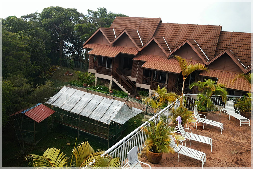
住宿
丽景湾酒店Jerail Hill Resort位置度假胜地店位于海拔1200米的日莱峰。酒店设有免费无线网络连接,还设有一个室外游泳池、儿童游乐场、水疗中心和室外露营地点。
丽景湾酒店Jerail Hill Resort位置度假胜地店位于海拔1200米的日莱峰。酒店设有免费无线网络连接,还设有一个室外游泳池、儿童游乐场、水疗中心和室外露营地点。
所有客房都配有典雅的木制家具、一台平面电视、迷你吧和一间私人浴室。连接浴室配备了24小时热水淋浴。
Puncak Kedah Restaurant餐厅供应国际美食。客人还可以通过客房服务在房间内用餐。酒店可应要求安排特别膳食餐点。
酒店还提供一间游戏室和乒乓球桌,自行车租赁服务和会议室。地理位置好!住过的客人都说和铅其他住宿相比,这家的位置棒棒哒。夫妻/情侣
特别喜欢这家住宿的位置,为两人住宿体验给出了8.9分
最佳探访季节
全年适合。山上气温凉爽,天气变化莫测,应准备御寒衣物和雨具。
全年适合。山上气温凉爽,天气变化莫测,应准备御寒衣物和雨具。
Planning
your Malaysia Cool Highland with Cheng Pai Voyage
城派梦想旅游策划您的马来西亚高原度假,
Cheng Pai Voyage 城派梦想旅游,
Dennis Loh, +6 012-359 1886
Ice Looi, +6 012-631 7638
Email : chengpai@gmail.com
Facebook : Cheng Pai Voyage
Wechat : chengpai60123591886 /
icelooi33
Whatspp / Line : 0123591886
We Welcome The World !


Comments
Post a Comment